ar3
Architecture Modeling
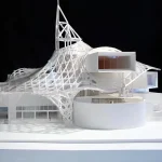
3D Printing in Architecture Modeling: A Revolution in the Making 3D printing is revolutionizing the way...
dental5
Dental
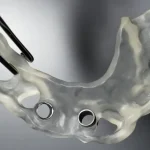
3D Printing in Dentistry Malaysia 3D printing is revolutionizing the dentistry industry in Malaysia....
Machinery Industry
Machinery
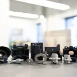
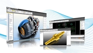
3D printing is revolutionizing the machinery industry, offering faster, more affordable, and more customized...
edu2
Education
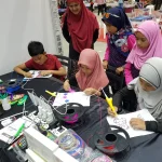
3D Printing in Education Malaysia: Transforming STEM Learning 3D printing is a rapidly evolving technology...
No posts found

SHARE SLAM S20

SHARE SLAM S20 – 3D LiDAR Scanner

  • Handheld & Portable – Lightweight design with ergonomic grip for easy field use

  • High Precision – Colorized point clouds with 1 cm accuracy and strong detail capture

  • Dual Fisheye Cameras – 16 MP ultra-wide lenses for immersive 3D visualization

  • Integrated RTK & SLAM – Real-time positioning and mapping for complex environments

  • Fast Workflow – SHARE Capture app + SHARE Pointclouds Studio for scanning, preview, processing, and export

  • Long Battery Life – Quick-release battery supports up to 2 hours of operation

Facebook
WhatsApp
Email
Twitter

Product Details

The SHARE SLAM S20 is a next-generation handheld 3D LiDAR scanner that revolutionizes on-site mapping. Combining high-precision LiDAR, wide-angle imaging, and a built-in RTK module, it delivers real-time colorized point clouds with industry-leading accuracy. Boasting a color point cloud thickness of just 1 cm and relative accuracy within 1 cm, the S20 ensures ridiculously precise spatial data. Equipped with dual ultra-wide 16-megapixel fisheye lenses, visual SLAM integration, and a convenient quick-release grip battery (up to 2 hours of runtime), it’s designed for intuitive, efficient use. Powered by the SHARE Capture mobile app and SHARE Pointclouds Studio software, professionals can seamlessly scan, preview, process, and export in common formats like .las, .ply, and .pcd. Ideal for architects, surveyors, and construction teams, the S20 transforms real-world environments into vivid, actionable 3D models, all in just one handheld device.

One-Inch Large-Format Image Sensor 

Equipped with dual one-inch large-format CMOS sensors, featuring 2.4μm pixel size and 16 effective megapixels per lens. This configuration delivers enhanced photo clarity and more accurate and clear point cloud colorization.

Professional-Grade Mechanical Shutter 

The mechanical shutter enables global exposure without jelly effect. This ensures more accurate colorful point cloud colorization and makes the photos highly suitable for nap-of-the-object photogrammetry modeling.

Precise Colorzed Point Cloud 

Featuring microsecond-level system-wide hardware time synchronization, this results in highly accurate point cloud data. It ensures seamless integration of color and intensity point clouds.

Open Hardware Interfaces 

Open hardware interfaces enable cross-platform collaboration. Open SDK supports device communication, data transfer and operational control, ideal for new surveying equipment (e.g.,embodied intelligence systems).

Supports Mesh Model Generation 

Raw data is fully accessible to software developers, allowing them to process the data using their own SLAM algorithms. The photos can be used for Mesh models, meeting the data processing needs across various industries.

Photos Support 3DGS Modeling 

Benefiting from the one-inch large-format camera and combined with image pose metadata technology, the photos are clear with uniform color. This makes them better suited for 3D Gaussian Splatting model generation.

Features Overview

Technical Specification

Specification Details
Dimensions 110.5 × 140 × 313.3 mm
Weight 1079 g
Battery Capacity 45.36 Wh (3150 mAh)
Working Time 150 min
Charging Port TYPE-C; PD 30 W fast charging
Working Temperature -20 ℃ ~ +50 ℃
Storage Temperature -20 ℃ ~ +60 ℃
Storage Capacity 256 GB (Supports memory expansion)
WIFI WIFI6, support 2.4G/5G; 20 m
Interface TF Card / Type-C
Camera Effective Pixels 16 MP × 2
Camera Sensor 13.13 × 8.76 mm; 1 inch
Shutter Type Mechanical shutter / Electronic shutter
LiDAR Installation Tilt 25° to the ground
Point Cloud Number 200,000 points/s
Point Cloud Frequency 10 Hz (Typical Value)
Scanning Range 0.1 ~ 40 m @ 10% reflectivity; 0.1 ~ 70 m @ 80% reflectivity
RTK Configuration Built-in standard configuration
RTK Accuracy Horizontal: 0.8 cm + 1 ppm; Vertical: 1.5 cm + 1 ppm
Point Cloud Thickness ≤ 1 cm
Processing Method Real-time calculation / Post-processing
Absolute Accuracy ≤ 5 cm
Relative Accuracy ≤ 1 cm

If you are looking for consumer range products please visit here: 3D Gadgets

Product Inquiry Form

SHARE SLAM S20

Thank you for signing up. You will be the first to know the Industry news, upcoming products, latest technology and special promotion.

Stay Tuned.

#image_title

Thank you! 

Your submission has been received. Someone from our team will contact you soon.

If you have any urgent issue,
please contat us by phone
@ +60 12716 8839